Below is the online edition of In the Beginning: Compelling Evidence for Creation and the Flood,
by Dr. Walt Brown. Copyright © Center for Scientific Creation. All rights reserved.
Click here to order the hardbound 8th edition (2008) and other materials.
Theories Attempting to Explain Ocean Trenches, Earthquakes, and the Ring of Fire
Two broad theories try to explain ocean trenches, earthquakes, and the Ring of Fire: the hydroplate theory, and the plate tectonic theory. Each explanation will be given as its advocates would. Then, we will test these conflicting explanations against observations and the laws of physics.
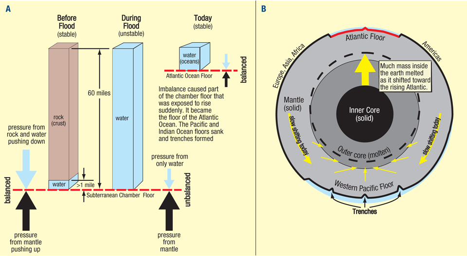
Figure 85: Hydroplate Explanation for Trenches. (A) Before the flood, the weight of rock and water, pushing down on the subterranean chamber’s floor, balanced the floor’s upward pressure. The rupture destroyed that equilibrium. Directly below the rupture, the imbalance grew as escaping, high-velocity water and the 60-mile-high, unsupportable, crumbling walls widened the globe-encircling rupture hundreds of miles. Eventually, the imbalance overwhelmed the strength of the floor. First, the Mid-Atlantic Ridge buckled, or sprang, upward. As Europe, Africa, and Asia slid eastward and the Americas plate slid westward (based on today’s directions), weight was removed from the rising floor, causing it to rise faster, accelerating the hydroplates even more. Pressure directly under the floor, represented by the large black arrows, naturally decreased as the floor rose.
(B) During the flood phase, the escaping subterranean water eroded and thinned the preflood crust to a thickness of about 30 miles. Frictional heating from movements near the center of the earth began melting solid rock which then contracted, because of the extreme pressure and magma’s great compressibility, contracted, as explained in “Magma Production and Movement” on pages 159–160. This caused the crust on the Pacific side of the earth (the Pacific plate ) to subside by at least 30 miles, fracturing the Pacific plate at thousands of places within the boundaries of the Ring of Fire! 13 That drop steepened the downhill slope of the sliding hydroplates, allowing them to slide into the Pacific region without major obstructions. Downward buckling and deep faulting formed trenches. All this melting lubricated the shifts inside the earth and allowed gravitational settling, which released much more heat, increased earth’s spin rate, and converted the inner earth to today’s inner and outer core—monumental changes. The thick layer of magma expelled up onto the top of the sunken Pacific plate provided most of the heat that drove the ice age and accounts for the almost 40,000 volcanoes on the Pacific floor. Even today, magma sometimes breaks out and escapes upward, heating part of the ocean and creating “El Niño” weather conditions.14
Magma Production and Movement
Magma’s Compressibility. Magma (melted rock inside the earth) is more compressible than the solid rock from which it came.2 Rock that melts under the extreme pressures more than 220 miles below the earth’s surface will contract! At depths of about 220 miles, melted rock occupies nearly the same volume as the original rock. At atmospheric pressure, rock expands by 7–17% (depending on the minerals present) when it is heated and melts. The density where the rock’s volume does not change as it melts is called the crossover density. Again, it depends somewhat on the minerals present. Because of magma’s compressibility, magma below this depth of about 220 miles is too dense to rise, so magma cannot circulate inside the mantle,19 contrary to what has been taught for 50 years!
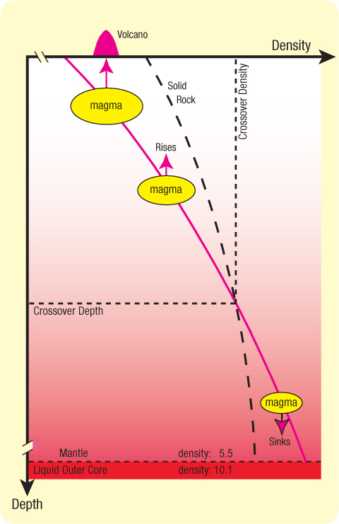
Figure 86: Crossover Depth. This graph shows how the density of liquid rock (magma) changes with depth below the earth’s surface. Above the crossover depth, magma is less dense than solid rock at the same depth and will try to rise through the cracks where the magma was produced by sliding friction; below the crossover depth, magma is denser than solid rock and will sink along those cracks toward the liquid outer core. Magma that drains down into the liquid outer core becomes almost twice as dense as the solid rock at the base of the mantle. [Note, at the bottom of the figure, the contrast in density (5.5-to-10.1) between the mantle and liquid outer core, and see the highlighted red cells on page 621.] Therefore, the mantle cannot circulate.
Nor was the mantle ever molten, because it would have expanded as it solidified, placing Earth’s crust in such extreme tension that it should have many mile-deep cracks.20
Earth’s magma began to be produced during the flood. [See "Melting the Inner Earth" on pages 620–623.] The magma’s final volume was more than 120 times greater than all the water in today’s oceans! With so much more liquid rock inside the earth than liquid water on earth, we need to understand how magma forms and why it moves.
Where Did All the Magma Go? The denser (deeper) magma and the denser unmelted minerals in the magma slowly drained into what grew to become earth’s outer and inner cores, respectively. The less dense magma that formed above the crossover depth tended to escape upward to the earth’s surface as volcanoes or flood basalts. For years after the flood, most eruptions spilled onto the Pacific floor—a floor littered today with 40,000 volcanic cones, each taller than 1 kilometer! The following analogy explains why.
A Cable Analogy. Imagine a long, unbreakable cable passing through the center of the earth before the flood. One end is anchored to the portion of the subterranean chamber floor that will rise to become the floor of the Atlantic Ocean. The other end attaches to the Pacific plate on the opposite side of the earth. When the Atlantic floor is forced upward at the end of the flood, the Pacific floor will be pulled down.
Gravity produces the same effect as our imaginary cable. Gravity creates so much compression deep inside the earth that voids cannot open up; rock is always squeezed against rock (including melted rock). However, compressed rock can shear. For example, if a heavy weight is on top of a deck of cards lying on a table, space cannot open up between the cards, but a relatively small horizontal force can cause a card to slip (or shear) relative to an adjacent card. Friction from shearing and deformations deep in the earth always melts the sliding surfaces. The magma produced then lubricates those surfaces, so they slip more easily.
Shearing. Now let’s imagine many evenly spaced cables connect the rising Atlantic floor to the broader, subsiding Pacific plate. (The upward pull from the rising Atlantic floor widens with depth;21 this is why the Pacific has a larger area than the Atlantic.) These cables shorten by varying amounts, because of variations in frictional heating along their lengths and magma’s compressibility. The farther a cable segment is from the Atlantic floor, the more likely it will move at a different rate than a corresponding segment on an adjacent cable, thereby shearing the rock between them, and produce magma. Each segment’s movement is the cable’s net expansion (or contraction) between the segment and the Atlantic floor. Therefore, the farther a segment is from the Atlantic floor, the more likely shearing becomes. Thus, shearing and magma production are extreme in and under the Pacific plate.
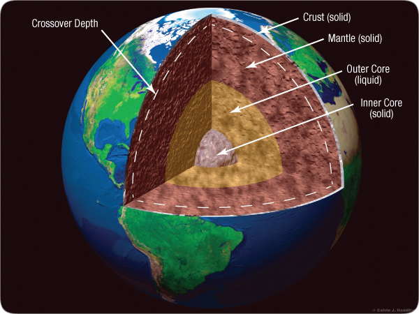
Figure 87: Inner Earth. The dashed white line marks the crossover depth. Magma generated above that line is less dense than the surrounding rock and will try to rise to the earth’s surface. Magma generated below that line contracts (becomes denser), so it drains through cracks into the outer core (a liquid). Standard explanations for today’s shifting continents and for so much liquid 1,800 – 3,200 miles under our feet are full of scientific problems.23 [See “Molten Earth” on page 30, and “Melting the Inner Earth” on pages 620–623.]
Large shearing offsets that reached the Pacific floor formed ocean trenches. Benioff zones under trenches are shearing surfaces (fault planes), not subducting plates, as commonly taught.22 Island chains often formed where magma escaped upward along these cracks. The Hawaiian Islands and the Emperor Seamounts are prime examples.
Deep Movements during the Flood Phase. As subterranean water escaped during the flood phase, the rupture steadily widened. This removed more and more weight from the chamber floor directly below, so that portion of the floor increasingly bulged upward. For a while, two types of forces resisted the rising of what would become the Atlantic floor: (1) the strength of the rock between that floor and the Pacific side of the earth, and (2) the weight of the stationary hydroplates that still lay above most of what would become the Atlantic floor.
Fractures and melting occurred deeper and deeper beneath the bulging chamber floor on the Atlantic side. Magma produced below the crossover depth contracted, so deeper fracturing, melting, and contraction occurred at an accelerating rate. By the end of the flood phase, the Pacific plate’s sagging foundation had fractured in millions of places, and the magma generated along the deep sliding surfaces instantly contracted. Therefore, the Pacific plate, lacking support, rapidly subsided and sheared around its perimeter—now called the Ring of Fire. This shearing suddenly increased the upward pressure under the rising Atlantic floor, so the hydroplates began to accelerate away from the rising Mid-Atlantic Ridge. That also removed weight from above the Atlantic floor, so it rose even faster.
Because so much compressible magma was quickly produced under the Pacific plate, that plate subsided (caved in) faster than the Atlantic floor rose. In hours, the downhill slope on which the hydroplates slid steepened, and the sheared Pacific Basin, surrounded by the Ring of Fire, became so deep that the hydroplates, sliding away from the rising Mid-Atlantic Ridge, met no major obstacles.
After the flood, magma under the Pacific floor, but above the crossover depth, erupted onto the Pacific floor. (To a much lesser extent, eruptions continue today, temporarily raising ocean temperatures in the western Pacific, a phenomenon called El Niño.14 ) Magma below the crossover depth drains down into the outer core, so the outer core is slowly growing today! Simultaneously, melting is shrinking the total volume below the crossover depth, so the crust must be compressing like the wrinkling skin of a drying (shrinking) apple. Also, continents, thickened during the compression event, are still sinking into and laterally displacing the mantle. Therefore, the mantle is being squeezed downward from above and upward by the growing outer core. Mantle volume is also being lost primarily from the Pacific mantle by draining below the crossover depth and by eruptions above the crossover depth. Therefore, the mantle is shifting an inch or so a year, generally toward the Pacific, to replace that escaping volume. [See Figure 94 on page 173.] These movements and stresses produce earthquakes. Slowly shifting continents led to the mistaken belief that the entire solid mantle somehow circulates as if it were a liquid—and, over millions of years, drifted continents over the face of the earth.
Eniwetok Atoll. Since the flood, magma that erupted onto the Pacific floor has raised sea level relative to the subsided Pacific plate that lies a few miles below the Pacific floor. This slow rise allowed today’s coral islands on top of tablemounts to grow upward—fast enough to maintain the sunlight they needed for optimal growth. The coral depth below one of these islands, Eniwetok Atoll, is 4,600 feet.24
Rapid Cooling. Some claim that if magma spilled out only about 5,000 years ago, heat would still be present. The lack of heat, they assert, shows that millions of years have elapsed. They have overlooked that magma’s contents: (a) crystals of unmelted minerals with high melting temperatures, (b) rock fragments, called xenoliths (ZEN-oh-liths), dislodged by the violent shearing and crushing, and (c) water absorbed by magma rising up through what remained of the subterranean water chamber. (This is why volcanoes emit so much water vapor; typically 70% of all gas released by volcanoes is water vapor.25) Because water dissolved in magma lowers its melting temperature, the magma remained a liquid at temperatures below the rock’s normal melting temperature. Also, the solid rock fragments in the magma absorbed heat, so the magma quickly cooled and solidified.
The Hydroplate Theory. [For a summary of the hydroplate theory, see pages 113–150.] At the end of the flood phase, unsupportable, crumbling walls and erosion from escaping high-velocity water had widened the globe-encircling rupture to an average of about 1,400 miles. Exposed at the bottom of this wide, water-filled gap was the subterranean chamber floor, about 60 miles below the Earth’s surface. Before the rupture, the weight of rock and water pressing down on the chamber floor balanced the upward pressure directly under the floor. [See Figure 85.] Afterward, with the overlying rock suddenly gone, only the strength of the upward-bulging chamber floor and the weight of some water resisted this upward pressure. As the rupture widened, the Mid-Oceanic Ridge suddenly buckled upward.[See pages 130–133.]
The continental-drift phase began with hydroplates sliding “downhill” on a layer of water, away from the rising Mid-Atlantic Ridge. This removed more weight from the rising portion of the subterranean chamber floor, lifting it faster, and accelerating the hydroplates even more. As that part of the chamber floor rose to become the Atlantic floor, it stretched horizontally in all directions, just as a balloon stretches when its radius increases. This stretching produced cracks parallel and perpendicular to the Mid-Oceanic Ridge, forming the overlapping spreading centers shown on pages 115 and 145. Rising began in the Atlantic, so the Mid-Atlantic Ridge and its cracks are the most prominent of the oceanic ridge system.
The rising Atlantic floor pulled even deeper material upward. Within the inner Earth, material shifted toward the rising Atlantic floor, a broader, but initially shallow, depression formed on the opposite side of the Earth—the basins of the Pacific and Indian Oceans. Just as the Atlantic floor stretched horizontally as it rose, the western Pacific floor compressed horizontally as it subsided (sank).
The slope between the upward bulging Atlantic floor and the subsiding Pacific floor steadily increased. (Figure 50 on page 117 shows one small, but telling, “snapshot” of what followed.) The instability that triggered the continental-drift phase was like that of a large, flat rock resting in the center of a horizontal teeter-totter. Slight imbalances (such as variations in the width of the rupture during the flood phase and the shifting of water from the Atlantic side to the Pacific side) will slowly tip our teeter-totter. A tipping point will be reached where the rock will rapidly accelerate downhill, so the tipping will increase even more. Although the Earth departed significantly from a spherical shape, gravity restored most of that spherical shape in the following months and years.
In the western Pacific, near the center of the combined Pacific and Indian Oceans, lies the trench region. As explained on pages 159–160, material beneath the western Pacific subsided at least 30 miles,13 so the Pacific plate sheared and buckled downward in some places, forming trenches. The Atlantic Ocean (centered at 21.5°W longitude and 10°S latitude) is almost exactly opposite this trench region (centered at 159°E longitude and 10°N latitude). [See Figure 83 on page 154.]
A simple, classic experiment illustrates some aspects of this event.
A cup of water is poured into an empty 1-gallon can. The can is heated from below until steam flows out the opening in the top. The heat is turned off, and the cap is quickly screwed onto the top of the can, trapping hot steam in the metal can. As this steam cools, a partial vacuum forms inside the can. The can’s walls buckle inward, forming wrinkles in the metal—“miniature trenches.”
The upper 5 miles of the Earth’s crust is hard and brittle. Below the top 5 miles, the large confining pressure will deform rock if pressure imbalances are great enough.29 So, as the western Pacific floor sank, it sheared and buckled into “downward creases,” forming trenches. The hard crust and deformable mantle frequently produced trenches with an “arc and cusp” shape. The brittle crust cracked and slid in many places, especially along paths called Benioff zones.30
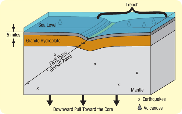
Figure 88: Trench Cross Section Based on Hydroplate Theory. Notice that the trench axis will generally not be a straight line. Sediments (green) hide the top of a fault plane that would otherwise rise a few hundred feet above the floor. Other sediments (not shown) and flood basalts (dark gray) cover most of the western Pacific floor. The three large black arrows show the direction of the rising Atlantic and the forces that downwarped the mantle and the Pacific plate. Earthquakes occur on the many faults produced, especially in Benioff zones and at low tides. Most volcanoes are not above Benioff zones, but are near a myriad of other faults near the center of the western Pacific, where there was considerable downwarping and shearing.
High-pressure deformations inside the Earth produced faulting and, therefore, extreme friction—and heat.
To appreciate the heat generated, slide a brick one foot along a sidewalk. The brick and sidewalk will warm slightly. Sliding a brick an inch but with a mile of rock squarely on top would melt part of the brick and sidewalk. Earth’s radius is almost 4,000 miles. Place a few thousand of those miles of rock on top of the brick and slide it only one thousandth of an inch. The heat generated would melt the entire brick and much of the sidewalk below.
Small movements deep inside the solid Earth, even microscopic, puttylike deformations, melted huge volumes of minerals. This released the water locked within the crystalline structure of certain minerals.
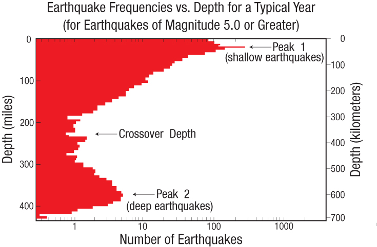
Figure 89: Earthquake Depths. Each earthquake begins at a point called the focus, somewhere below the earth’s surface. Wouldn’t you expect that most foci occur at a certain depth, or that they increase or decrease with depth. Surprise! For earthquakes with a magnitude of 5.0 or more, there are two peaks. In other words, earthquake foci are bimodal with depth.40
The fact that there are two peaks—one 22 miles (35 kilometers) below the earth’s surface and the other at 370 miles (600 kilometers) below—tells us that two types of earthquakes occur, each at a different depth. The hydroplate theory explains both conditions and why conventional geophysics does not explain the root cause of earthquakes.
Shallow earthquakes (above depths of 220 miles) involve only brittle fracture and sliding friction.41 However, cracks or space should not open up to allow movement for deep earthquakes where pressures are extreme. Geophysicists have tried for more than 80 years to explain why earthquakes occur at 220–410-mile depths .42 Those rocks should be so hot that they would not break, but would deform like hot tar—slowly and quietly.Those earthquakes occur where pressure and heat should cause rocks to deform and flow before enough stress can build up to cause failure. How then do deep earthquakes occur?
Here’s a clue based on the hydroplate theory. Few earthquakes occur at 220 mile depths—the crossover depth—because magma produced along faults at that depth has little tendency to rise or sink. Magma above 220 mile depths expands and tries to rise to the earth’s surface. Magma below 220 mile depths contracts and drains into the outer core. Figure 90 completes the answer.]
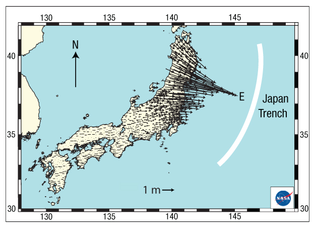
Figure 90: Strange Displacements during the 9.0 magnitude, 11 March 2011 Japanese Earthquake. The Japanese government, using the Global Positioning System (GPS), continuously measures the location of 1,200 points to an accuracy of better than an inch. Each arrow above shows the direction and distance that a point on the ground moved during that earthquake. Some points moved 18 feet (5.5 meters)! Horizontal movements appear to converge toward the epicenter, Point E. The actual earthquake began at the focus, 20 miles below Point E (below the earth’s surface), on the fault (the Benioff zone) that descends from the Japan Trench—down and to the west, under Japan.
How can rock suddenly converge radially toward a point? Obviously, rock near the focus, far below Point E, must have been removed to make room for the convergence—to allow the surrounding rock to collapse. As discussed on page 159, frictional heating along the fault first melts grain-sized minerals with the lowest melting temperatures, causing them to expand, because they were above the crossover depth. (Remember: Tiny movements at the extreme pressures deep in the earth produce great heat and melting.) Minerals with higher melting temperatures remain solid, maybe for centuries, thereby encasing and trapping the tiny droplets of melted rock. [See "Liquid Droplets Seen in Hot, Compressed Rock" on page 163.]
If frictional heat steadily “soaks” into the rock on both sides of a fault, magma droplets will increasingly form, so sooner or later, leakage will begin. Paths will open up for the expanding melt to escape upward buoyantly. The highly compressed solid “scaffolding” (surrounding the focus and composed of minerals with the highest melting temperatures) will become unstable and eventually collapse. Frictional heating will instantly become extreme, so all nearby minerals will suddenly melt. The result: a powerful earthquake.
Similar events occur below the crossover depth, except there the melted minerals “shrink” (become denser), and slowly drain along faults down into the outer core. This ongoing process releases gigantic amounts of heat throughout the mantle and core,46 and will eventually produce many powerful earthquakes. However, when that will happen is uncertain.47

PREDICTION 8: By 2020, satellites in low-earth orbits will predict the location of major earthquakes several days beforehand. They will do this by measuring electrical changes in the ionosphere that are produced by piezoelectric voltages building up in stressed rock around the focus of the coming earthquakes. If the focus is above the crossover depth, which is 220 miles below the earth’s surface, upward escaping magma may also produce detectable heat around the epicenter days beforehand.
Suppose the inner Earth initially had a more uniform mixture of minerals. Heating would first melt minerals with lower melting temperatures, which would allow denser grains to settle and lighter grains to rise, a process called gravitational settling. This would generate much more heat and produce more faulting, melting, and gravitational settling. After many such cycles, the Earth’s core would form with solid, denser minerals (containing iron and nickel) settling to form the inner core and the melt forming the liquid outer core. Shifting so much mass toward the center of the Earth and doubling the density of the rock melting below the crossover depth would increase Earth’s rotational speed, just as the skater in Figure 84 on page 156 spins faster as she draws her arms closer to her spin axis.
In the mid-1980s, seismologists noticed that seismic waves pass through the inner core about 4 seconds faster when traveling along the axis of the magnetic poles.31 Other tests showed that this was because crystals in the inner core have a preferred orientation.32 That direction is slowly changing by about 0.4° per year,33 so the inner core is spinning slightly faster than the rest of the Earth.34 It can do this because the liquid outer core allows slippage. "The Origin of Earth’s Powerful Magnetic Field" on page 180 explains how this alignment of crystals arose. Other evidence, explained in Endnote 23, supports these powerful movements inside the Earth. Today, the Earth spins 365.256 times each year, but there are historical reasons for concluding that a year once had 360 days.35 [For details, see "Melting the Inner Earth" on pages 620–623.]
Forming the Core
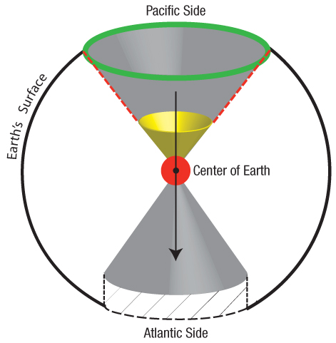
Figure 91: Concentrated Stress, Deformation, and Heating at Earth’s Center. When the flood began, the fountains of the great deep steadily eroded and widened the rupture, especially in what is now the center of the Atlantic, (shown by the cross-hatched region). Eventually, weight pressing down on the center of the earth from the Pacific side was so much greater than the weight pushing down from the Atlantic side that rock was extruded through the center of the earth toward the Atlantic side. That rock instantly melted and shrank by about 50%, because it was so far below the crossover depth. This was the beginning of earth’s core, shown as the red circle.39
With the collapse of the deepest foundations on the Pacific side of the earth, a runaway situation quickly developed in which deep shearing, frictional heating, and shrinkage produced more shearing, frictional heating and shrinkage. The shrinkage within the yellow cone region caused the sides of the gray Pacific cone (marked by the dashed red line) to shear. This produced the Ring of Fire, shown in green, and dropped the Pacific plate at least 30 miles. Simultaneously, the Atlantic floor rose.
In this simplified (not to scale) illustration, assume that all movement was in the general direction of the long black arrow and confined within the two gray cones whose apexes met at the center of the earth. Obviously, runaway melting began near the center of the earth, where pressures and deformations were greatest.
For over two centuries, textbooks and popular media have taught that the earth evolved by meteoritic bombardment. If that had happened, all earth’s material, falling in from outer space, would have generated enough heat to have melted the earth several times over.36 Supposedly, over billions of years, most of the earth cooled and solidified, so only the outer core is still molten. This explanation for earth’s core has four fatal problems:
- The inner core is also a solid. For it to solidify, too much heat would have to be conducted away from the center of the earth—a process so slow that it can be considered impossible in less than a hundred billion years.37
- A molten earth would have evaporated all earth’s water and produced a runaway greenhouse. Earth’s atmosphere would still be so hot that life on earth would be impossible. [See “Consequences of Evolving Earth by Meteoritic Bombardment” on page 626.]
- Had the earth ever been molten, we should not find dense nonreactive minerals (such as gold) at earth’s surface; those minerals would have settled into the core.
- Had the earth ever been molten, siderophile (or iron-loving) elements—found in the mantle— would have combined with iron and have settled into the core.38
Other problems with this explanation are given in “Molten Earth?” on page 30. So how did earth’s core form?
As the rupture widened during the flood, the floor of the subterranean chamber suddenly bulged upward under the entire length of the 46,000-mile-long rupture (as shown in Figure 63 on page 130 and Figure 65 on page 131). At the center of the earth, where pressures are extreme and stresses and movements are focused, frictional melting began. Pressures are so great near the earth’s center that even slight movements between adjacent molecules produce heating, melting, and (as explained on page 159) shrinkage. This was the beginning of the earth’s core.
Crystals with lower melting temperatures melted first. The magma produced then surrounded other crystals, shielding them from further shearing stresses and frictional heating. The denser, unmelted crystals settled through the melt, initiating the crystalline growth of the solid inner core. This is why a “giant crystal” is at the center of the earth and why earthquake waves travel much faster through the inner core along “the axis of the magnetic poles” than in the perpendicular direction.31,32 Crystals less dense than the melt floated to the top of the melt and pressed against the bottom of the mantle. This is the origin of the ultralow-velocity zone, the 200-km-thick D" layer at the base of the mantle. Seismic waves travel more slowly through D", because it consists of slushy, magma-saturated sediments.
Material melting near the center of the earth (far below the crossover depth) shrank, producing even more plastic deformation and melting in the rock immediately above. For a time, runaway melting occurred, especially on the Pacific side of the earth.
Throughout the flood, the chamber floor increasingly bulged upward, producing fractures that grew deeper as the rupture widened. Eventually, deep shear fractures connected with the growing outer core. Those drainage channels remain today for magma (produced below the crossover depth) to drain down into the outer core. As will soon be explained, these deep channels play a key role in earthquakes, earth’s magnetic field, and the slow shifting of the continents. Misunderstanding the cause of these shifts led to the erroneous theory of plate tectonics.
Shrinking Earth. The liquid outer core has a volume of 4.1 × 10¹⁰ miles3 (1.7 × 10¹¹ km3)—7.7 times the volume of our moon. The outer core’s density is almost twice that of the mantle rock from which it came. Therefore, before the core formed, the preflood Earth’s volume was almost 4.1 × 10¹⁰ miles3 greater, so the Earth’s radius was about 180 miles larger than today. The Earth shrank.
Undoubtedly, most of this shrinkage occurred during and soon after the flood, as the mantle lost about twice the volume that the dense core gained. Earthquakes still occur, so the Earth is still shrinking, because slight amounts of relatively low density mantle rock below the crossover depth are still becoming high density magma draining into the outer core.
Can this shrinkage be measured? Marginally. The best (and highly impressive) measurements in changes of the Earth’s radius were conducted in 2000 and 2005 by the International Earth Rotation and Reference Systems Service in Paris, France,43 using seventy stations around the world. Those measurements (based on Satellite Laser Ranging, Very Long Baseline Interferometry, and the Global Positioning System) showed a 0.2 inch (5 millimeters) shortening of Earth’s radius during those 5 years. However, more accurate techniques were used in 2005, so the shortening may be due to improved accuracy. Future measurements should clarify the amount of shrinkage.
Before plate tectonics became popular, some geologists said that many of the Earth’s surface features were a result of past shrinkage deep within the Earth.44 Among the many crustal features they felt this would explain were ocean trenches, tablemounts, and the dropping of the Pacific Basin as one huge block. Most of those geologists believed that a molten Earth shrunk as it cooled over millions of years. However, because they could not provide convincing details, their idea has fallen into disfavor. [The belief in a molten Earth can be easily rejected. See “Molten Earth” on page 30.] Nevertheless, the idea of millions of years has remained in most people’s imaginations.
PREDICTION 9: The mean radius of the Earth has shrunk about 180 miles since before the flood. Earth is still shrinking, but at a much slower rate.
While these geologists did see evidence of shrinkage, they were reasoning only from the effects they saw back to possible causes. Had they also arrived at a consistent picture by reasoning from cause to effect and not been satisfied until the forces, energy, and mechanisms were understood, they would have been on firmer ground.
What caused the shrinkage? The greatest movements (within the Earth) caused by the rising Atlantic floor would have been at the center of the Earth. [See "Forming the Core" on page 164.] Also, the center of the Earth, where pressures are greatest, would have produced the greatest melting and shrinkage. Even slight movements of one mineral grain relative to an adjacent grain at those extreme pressures will produce instant melting followed by about 50% shrinkage. [See "Magma Production and Movement" on page 159.]
As the Atlantic side of the inner Earth rose, the Pacific side of the inner Earth had to collapse onto the magma forming and shrinking near the center of the Earth. This runaway subsidence, melting, and shrinkage fractured and distorted much of the Pacific side of the Earth—especially the brittle Pacific crust. Because the Pacific crust would not have dropped as “one huge block” (as early geologists thought), its thousands of fragments, buried under and within the magma that rose to the surface, will be difficult to detect seismically. However, the largest block, greater in area than India, is now recognized as a 94% submerged continent called, Zealandia.48 Researchers are also detecting some granite under the floors of the Pacific and Indian Oceans.49
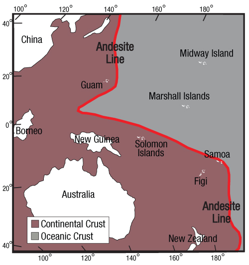
Figure 92: Andesite Line. This sharp discontinuity (shown in red) in the western Pacific was identified in 1912 by the famous New Zealand geologist, Patrick Marshall. The andesite line is considered “the most significant regional geologic distinction in the Pacific Ocean Basin,”95 although the term andesite line has fallen into disuse among plate-tectonic advocates.
Volcanic islands to the east of the andesite line are basaltic, while islands to the west are made of andesite, a type of rock named for its presence in the Andes Mountains. Andesite contains minerals, such as hornblende and biotite, that are not in basalt but are in granite (continental rock). Despite its significance, geologists have never explained why continental crust lies below the western Pacific.
Indeed, the presence of andesite, a fine-grained mixture of granite and basalt, west of the andesite line shows that at least fragments of continental rock (primarily granite) lie below the floor of the entire western Pacific. [See Figure 92.]
The types of rock found on [western Pacific] islands help to determine the edge of the Pacific Basin. The andesite line has on its ocean [eastern] side rocks composed primarily of basalt, whereas on the other [western] side they are principally andesite. This has been viewed as the dividing line between oceanic and continental crusts.” 50
For the most part, the andesite line also marks the true limit of the continents.51
Trenches formed and plates moved by the power of gravity. Gravity always tries to make the Earth more compact (or spherical).52 If you suddenly removed a bucket of water from a swimming pool (or even a 60-mile-thick layer of rock lying above what is now the Atlantic floor), gravity would tend to smooth out the irregularity. Because massive volumes of rock inside the Earth do not flow as fast as water in a swimming pool, mass deficiencies, which we might think of as slight partial vacuums, still exist under trenches. Today, especially at low tide (when the water’s pressure on the ocean floor is a minimum), mantle material slowly seeps in under trenches to reduce these “partial vacuums.” This stretches the crust above, produces extensional earthquakes near trenches, shifts plates toward trenches, and makes the Earth measurably rounder.53
Both the hydroplate theory and the plate tectonic theory are explained as their advocates would explain the theories. One should critically question every detail of both theories, and not accept either until all available evidence has been considered.
The Plate Tectonic Theory. Earth’s crust is broken into rigid plates, 30–60-miles thick, some with an area roughly the size of a continent. Some plates carry portions of oceans and continents. Plates move relative to each other over the Earth’s surface, an inch or so per year.
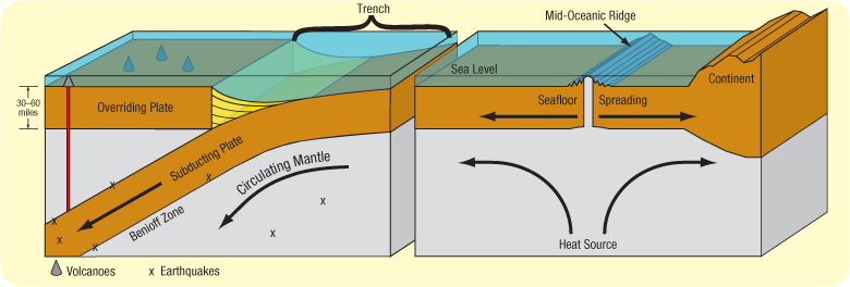
Figure 93: Plate Tectonic Explanation for Trenches. Internal heat circulates the mantle, causing large plates to drift over the earth’s surface. Consequently, material rises at oceanic ridges, forcing the seafloor to spread, so plates must subduct at ocean trenches, allowing layered sediments, shown in yellow, to collect. Earthquakes usually occur where plates subduct (Benioff zones) and at other plate boundaries. Subducting plates also melt rock, and the resulting magma rises to form volcanoes.
[Response: Actually, most volcanoes are not above Benioff zones. If this theory were correct, the yellow sediments would hide a cliff face that is at least 30 miles high and the trench axis should be a straight line. Also, some very large earthquakes occur far from plate boundaries. The powerful New Madrid, Missouri earthquakes of 1811 and 1812 and Charleston, South Carolina earthquake of 1886 are famous examples.]
Trenches formed and plates move by heat from radioactive decay. Just as hot water circulates in a pan on a stove, hot rock circulates slowly inside Earth’s mantle. Radioactive decay warms some parts of the mantle more than others. The warmer rock expands, becomes less dense (more buoyant), and slowly rises, as a cork rises when submerged in water. Sometimes, plumes of hot rock rising from the outer core break through the Earth’s crust as flood basalts. Conversely, relatively cold rock descends. Rising and descending rock inside the mantle forms circulation cells (convection cells) which drag plates forward. Currents within the mantle rise at oceanic ridges, create new crust, and produce seafloor spreading.
Because new crust forms at oceanic ridges, old crust must be consumed somewhere. This happens wherever two plates converge. The older plate is denser, because it had more time to cool. Therefore, it sinks below the younger plate and subducts into the mantle, forming a trench. A cold, sinking edge will pull down the rest of the plate and enhance circulation in the mantle. Earthquakes occur under trenches when subducting plates slip along Benioff zones and when plates slip past each other. At great depths, subducting plates melt, releasing magma, which migrates up to the Earth’s surface to form volcanoes. Most of the Ring of Fire is produced by subducting plates. Such slow processes require hundreds of millions of years to produce what we see today.