Below is the online edition of In the Beginning: Compelling Evidence for Creation and the Flood,
by Dr. Walt Brown. Copyright © Center for Scientific Creation. All rights reserved.
Click here to order the hardbound 8th edition (2008) and other materials.
A Few of the Mysteries
The Grand Canyon and Other Canyons. See Figure 43.
Mid-Oceanic Ridge. This 46,000-mile-long ridge, discovered in the 1950s, is the world’s longest mountain range. It wraps around the earth on primarily a great-circle path. [See Figure 46 on page 115.] Unlike most mountains, it is composed of a type of rock called basalt. Because most of the ridge lies on the ocean floor, relatively few people know it exists. How did it get there? Why is it primarily on the ocean floor? Why does it intersect itself in a Y-shaped junction in the Indian Ocean? The portion in the Atlantic Ocean is called the Mid-Atlantic Ridge. Is it just a coincidence that it splits the Atlantic from north to south and is generally perpendicular to and bisected by the equator? If Europe, Africa, and the Americas were once connected, how did they break apart?
Cutting across the Mid-Oceanic Ridge, at almost right angles, are hundreds of long cracks, called fracture zones. Whenever the axis of the Mid-Oceanic Ridge is offset, it is always along a fracture zone. [See Figure 46 on page 115.] Why? According to plate tectonics, plates move parallel to fracture zones. But fracture zones are not always parallel. Sometimes they are many degrees “out of parallel.”6 How then can solid plates be bounded by and move in the direction of these fracture zones? (Can a train move on tracks that aren’t parallel?) Notice the white arrows in Figure 46 showing nearly intersecting fracture zones.
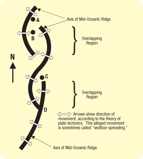
In at least eight places on the Atlantic and Pacific floors, segments of the Mid-Oceanic Ridge overlap for about 10 miles. They are called overlapping spreading centers.7 [See Figure 46.] If plates are moving away from the Mid-Oceanic Ridge, then the distance between overlapping segments must be increasing. However, overlapping regions are always near each other—contradicting plate tectonics.

Figure 46: Overlapping Spreading Centers. Bold lines represent the axes of the Mid-Oceanic Ridge. According to plate tectonics, the ocean floor is moving in the direction of the white arrows—away from the Mid-Oceanic Ridge. If so, in which direction is point B moving? If B is stationary, and A is moving east, why is there no fault between them? What is happening at C and D if the plate tectonic theory is correct? Obviously, the sea floor is not spreading. Later, these overlaps will be shown to support the hydroplate theory.
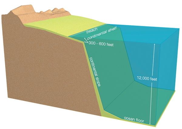
Earth’s Major Components. What accounts for earth’s oceans, continents and their boundaries (shelves and slopes), crust, mantle, and core (inner and outer)? Why are the shapes of continental shelves and slopes so uniform worldwide? [See Figures 44 and 47 and Figure 87 on page 160.]
Low-salinity water is being discovered far below continental shelves worldwide. Why would water, typically less salty than sea water, be found beneath the sea floor?8

Figure 47: Continental Margin. The typical shape of ocean-continent boundaries worldwide is shown here. The actual continental boundary is generally considered to be halfway down the continental slope. Compare this figure with Figure 44 on page 114, and notice that Asia and North America would become connected by a wide land bridge if sea level were lowered about 300 feet. Australia and Asia would be almost connected. Sediments and sedimentary rock are shown in yellow.
With so much ice on the continents during the height of the ice age (a few centuries after the flood), sea level was temporarily about 400 feet lower than it is today. Therefore, land animals and humans could then have easily migrated between all continents.
Ocean Trenches. Ocean trenches are long, narrow depressions on the ocean floor, some of which are several times deeper than the Grand Canyon. They can be seen in the western Pacific in Figures 44, 45, and 83. Plate tectonics claims that a trench forms when a plate dives down into the mantle at a 30°–60° angle below the horizontal, a process advocates call subduction. How this dive begins is never explained. This would be similar to pushing a 30-mile-thick shovel into the ground. What pushes a continental-size plate down at such a steep angle? If subduction occurs, why do instruments detect almost no distortion of the horizontal sedimentary layers in trenches? Worse yet, if any plate reached a depth of only several miles, pressures would be so great that frictional forces would exceed the rock’s strength. Therefore, large-scale sliding of a relatively thin slab by pushing, pulling, or dragging should be impossible. [See page 610.] This is similar to trying to push our 30-mile-thick shovel, now pinched in the jaws of a vise, down farther. It may break, buckle, deform, or crush, but it will not slip. (The next chapter will show that deep faults have been misinterpreted as subducting plates.)
Magnetic Variations on the Ocean Floor. At a few places along the Mid-Oceanic Ridge, magnetic patterns on one side of the ridge are almost a mirror image of those on the other side. The plate tectonic theory gained wide acceptance in the 1960s when this surprising discovery was misinterpreted.
Some people proposed that these variations were caused by periodic reversals of the earth’s magnetic field, although there is no theoretical understanding of how that could happen.9 Supposedly, as molten material moves away from the ridge (in seafloor spreading) over millions of years, the magma solidifies, and its magnetic material is locked in the orientation of the earth’s magnetic field at the time. Thus, a record of past “flips” of earth’s magnetic field is preserved in rocks at different distances from the ridge.

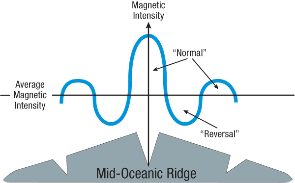
Figure 48: Magnetic Anomalies. Notice the fluctuations in magnetic intensity as one moves across the Mid-Oceanic Ridge. The so-called reversals are simply regions of lower magnetic intensity. Why is the intensity greatest along the crest of the ridge?
That explanation is wrong, as detailed magnetic maps clearly show. No compass, shielded from earth’s magnetic field, would reverse direction whenever it crossed an alleged (and misleading) reversed band. However, as one moves across the Mid-Oceanic Ridge, magnetic intensities fluctuate, as shown in Figure 48. Someone merely drew a line through these fluctuations and labeled everything below this average intensity as a “reversal.” There is a false but widespread impression that these slight deviations below the average represent magnetic fields that reversed millions of years ago. Calling these fluctuations reversals causes one to completely miss a more likely explanation.
Although textbooks show these so-called “reversals” as smooth bands paralleling the Mid-Oceanic Ridge for thousands of miles, there is nothing smooth about them. Some “bands” are even perpendicular to the ridge axis—the opposite of what plate tectonics predicts. Also, the perpendicular “bands” correspond to fracture zones.10 The hydroplate theory offers an explanation for these magnetic anomalies. [See "No Seafloor Spreading" on page 176.]
A few lava flows show that rapid but limited changes in earth’s magnetic field have occurred. Lava cools at known rates, from the outside of the flow toward its center. Magnetic particles floating in lava align themselves with the earth’s magnetic field. When the lava cools and solidifies, that orientation becomes fixed. Knowing this cooling rate and measuring the changing directions of the magnetic particles within several solidified lava flows, shows that at one time earth’s magnetic field shifted rapidly—by up to 6 degrees per day for several days.11 (Note: This does not mean earth’s magnetic field periodically flips.)
Submarine Canyons. The ocean floor has hundreds of canyons, some that exceed the Grand Canyon in both length and depth. One submarine canyon is ten times longer (2,300 miles), so long it would stretch nearly across the United States.12 Many of these V-shaped canyons are extensions of major rivers. Examples include the Amazon Canyon, Hudson Canyon, Ganges Canyon, Congo Canyon, and Indus Canyon. How were canyons gouged out, sometimes 15,000 feet below sea level? Did ancient rivers (or major drainage paths) cut these canyons when sea level was lower or the ocean floor was higher? If so, why did those elevations change? Swift rivers supposedly cut most continental canyons. However, currents measured in submarine canyons are too slow, generally less than one mile per hour. Frequently, the flow is in the wrong direction. Submarine landslides that produce dense, muddy currents sometimes occur. However, they would not form the long, tributary patterns that characterize river systems and submarine canyons. Furthermore, experiments with thick, muddy water in submarine canyons have not demonstrated any canyon-cutting ability.
Coal and Oil Formations. Large fossilized trees are found near the North and South Poles.13 In Antarctica, some fossilized trees are 24 feet long and 2 feet thick! Nearby are 30 layers of anthracite (or high-grade) coal, each 3–4 feet thick.14 Buried redwood forests, with trees more than 100 feet long and root structures showing that they grew in place, are found on Canadian islands well inside the Arctic Circle.15 Much oil is also found inside the Arctic Circle. Was it once warm enough for trees to grow in Antarctica or inside the Arctic Circle? If so, how could so much vegetation grow where it is nighttime 6 months of the year? Were these cold lands once at temperate latitudes? Not according to plate tectonics, which places both regions near their present latitudes when their now-fossilized forests were growing.16
Methane Hydrates. Some bacteria can live without oxygen. They feed on organic matter and produce methane gas, a combustible fuel. Since 1970, methane has been discovered inside ice mixed within sediments lying up to 8,000 feet below the deep ocean floor off coastlines.17 The ice molecules form microscopic cagelike structures encasing one or more methane molecules. The total energy value of this methane-ice combination, called methane hydrate, is at least twice that of all the world’s known coal and oil combined!18

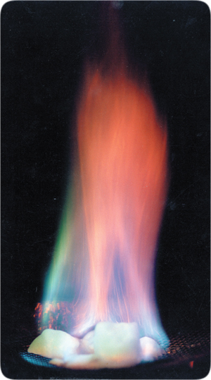
Figure 49: Flaming Ice. This ice contains methane, a flammable gas. Water will freeze at slightly warmer temperatures than normal if it is under high pressure and contains dissolved methane. Such temperatures and pressures exist 2,000 feet or more below sea level. There, vast methane deposits are found trapped in ice on and under the deep seafloor, primarily along coastlines. How did so much methane get there?
Why is so much methane buried along coastlines? How did all the bacteria, that produced the methane, get there, and what was their gigantic source of food? The largest single deposit known, named “Hydrate Ridge,” lies off Oregon’s coast. According to plate tectonics, that part of the seafloor is sliding under North America, and should be removing the methane hydrates. However, there is —along all coast lines worldwide, just as there are where seafloors are not supposedly subducting. [See Figure 49.]