Below is the online edition of In the Beginning: Compelling Evidence for Creation and the Flood,
by Dr. Walt Brown. Copyright © Center for Scientific Creation. All rights reserved.
Click here to order the hardbound 8th edition (2008) and other materials.
Could Earth’s Mountain Ranges Form in Less Than an Hour?
If you are surprised (or doubt) that all of Earth’s major mountains ranges formed in less than an hour, then let’s begin with something easier to visualize and analyze.
The reason the events of the flood have, for centuries, remained hidden—and for many, unbelievable—is because of the flood’s magnitude. Its global extent, gigantic forces, energy, and extreme and diverse consequences were far beyond our everyday experiences, even though the flood is etched in the memory of most cultures and religions.
So let us
a. start with the main assumption on page 122,
b. never violate a law of physics,
c. consider all relevant scientific evidence (what we can see and measure today and that others can verify),
d. not be afraid to think big or follow the evidence, and
e. not be distracted by those who refuse, or are unable, to follow the above steps.
We will see many confirmations that we are on the right track, because the consequences of the flood solve hundreds of mysteries that have perplexed scientists for centuries, if not millennia. However, to do this, we must be willing to think across multiple scientific disciplines.
An Analogy. Imagine that a long, massive train lost its brakes and is steadily gaining speed as it accelerates down a high mountain. Eventually, this runaway train will crash. Its many boxcars will suddenly decelerate, compress, crush, and jackknife. In this analogy, the mountain the train is racing down represents the steep slope from the suddenly upbuckled Mid-Atlantic Ridge. Tipped and crushed boxcars represent today’s compressed and buckled mountain ranges. [See, for example Figure 50 on page 117. Thousands of other examples could be given.]
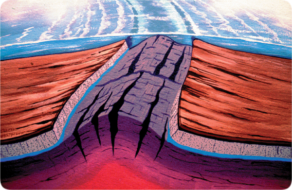
The flood began with the globe encircling rupture. The escaping fountains of the great deep eroded and widened the rupture, which removed weight from the chamber floor directly below the rupture. Eventually, the Mid-Atlantic Ridge sprung upward. As shown in Figure 91 on page 164, this pulled the Pacific plate down steepening even more the hydroplates slide down and away from the rising Mid-Atlantic Ridge. (The Americas hydroplate plate slid west, and the Europe/Asia/Africa hydroplate slid east.) Within one day,1 the Atlantic basin opened up.

Figure 239: Birth of Mid-Atlantic Ridge and the Ultimate Slippery Slope. Ice is slick, especially if one is on ice skates, because ice directly under the great pressure of the thin metal blades normally turns to liquid water. Ice skaters are actually sliding on liquid water.
Imagine how fast a skater—or massive hydroplate—would slide down a mountainside the size of the Mid-Atlantic Ridge, riding not on liquid water but on supercritical water (SCW), which is 50 times slicker than liquid water! SCW has a viscosity (frictional resistance) about one-fiftieth that of liquid water; SCW provided almost no resistance to the massive sliding hydroplates; it was much like riding a few thousand miles down a steep slope on a cushion of air.
Contrast that with the century-old problem geologists have trying to understand how 30–60-mile thick, continental plates can scrape over and plow through mantle rock, which is a solid, not a liquid. Obviously, the plates cannot. Geologists have a serious problem.
Our fictitious train has the mass of a continent and our mountain rises from the floor of the subterranean chamber, directly below the widening rupture and 60 miles below earth’s preflood surface. [See Figure 239.] Some have wondered why the Mid-Atlantic Ridge is much higher and steeper than the rest of the Mid-Oceanic Ridge. It is because the Mid-Atlantic Ridge rose first and relieved much of the internal upward pressure on the rest of the Mid-Oceanic Ridge.
The hydroplates accelerated much faster than our fictitious train, because a train has many moving, grinding parts, including metal wheels that roll noisily on metal tracks bending around curves. All of that creates friction; the faster the train, the greater the friction. However, as explained in Figure 239, the hydroplates (our real train) slid straight down the ultimate slippery slope—which was supercritical water, 50 times slicker than ice.2
When one compares the gigantic mass of our continental-size train (the driving force) with the almost negligible resistance from the slippery slope, friction can safely be neglected. Therefore, the speed of our fictional train depends only on gravity and the downhill slope from the center of the rising Mid-Atlantic Ridge to the sunken Pacific plate.
How long was the continental-drift phase? Our fictional train accelerates faster than a steel ball rolling straight down such a slope.4 Initially, the speed is slow, but every second it increases, until resistance is met and the compression event begins. The continental-drift phase lasted no more than 24 hours.1 Figure 50 on page 117 shows one of the consequences.
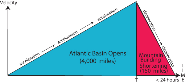
How rapidly did earth’s mountains form? Although our runaway train picked up speed slowly, if, after hours of acceleration, its wheels suddenly fell off, the train would rapidly decelerate and crash. Likewise, the compression event began after most of the Atlantic had opened up. The hydroplates began to meet major resistances, ran out of lubricating water, decelerated, crushed, and buckled. Earth’s mountain ranges were pushed up in less than an hour—all with fossils of sea life on top. [See Figure 240.]

Figure 240: Timing of Events, Continental-Drift Phase. This velocity-time diagram (used frequently by engineers) allows us to estimate how rapidly mountain ranges formed. With this type of diagram, positive slopes represent acceleration, and negative slopes, deceleration. The colored areas represent distances traveled. The acceleration portion of the continental-drift phase (shown in blue) opened up the 4,000 mile wide Atlantic basin in T hours. The entire continental-drift phase lasted somewhat less than 24 hours.1 The decelerating portion (shown in red), which pushed up all of earth’s major mountain ranges, lasted less than (24 - T) hours. Researchers have estimated how much mountain building has shortened continents on various great circles. These estimates generally range between 100 and 200 miles.3 If we took the average of these two distances (150 miles) and both the acceleration and deceleration were constants, then the compression event and mountain building lasted less than an hour—or more precisely, less than 0.87 hours. If you calculate the height of the two triangles, you will see that the maximum velocity of each hydroplate was about 170 miles per hour!
This is consistent with Genesis 8:1 which says that a great wind “passed over the earth” at the end of the flood. We live under an “ocean” of air—our atmosphere. The extremely rapid uplift of all earth’s major mountain ranges displaced the atmosphere, causing great winds to flow down the rising mountains. It was like a global tsunami, but instead of an earthquake suddenly lifting a portion of the ocean floor and creating a tsunami (a giant water wave that travels thousands of miles), the compression event suddenly uplifted earth’s major mountain ranges and produced a great “wind that passed over the earth.” Had mountains been pushed up slowly—the conventional view—that extreme wind within the atmosphere would not have happened.
Some who read that a great “wind passed over the earth” at the end of the flood think that is one more reason to regard the flood account as mystical or unrealistic. Instead, gigantic events were happening that we don’t experience today. The flood account is quite accurate. In fact, the flood year is the most precisely recorded year in the Bible.