Below is the online edition of In the Beginning: Compelling Evidence for Creation and the Flood,
by Dr. Walt Brown. Copyright © Center for Scientific Creation. All rights reserved.
Click here to order the hardbound 8th edition (2008) and other materials.
Liquefaction During the Compression Event
While liquefaction operated during the flood phase, it acted massively once during the compression event, at the end of the continental-drift phase. [See pages 113–150.]
Visualize a deck of cards sliding across a table. Friction from the table slows the bottom card. That card, in turn, applies a decelerating force on the second card from the bottom. If no card slips, the entire deck, including the top card, will decelerate as a unit. But if a lubricant somehow built up between any two adjacent cards, cards above the lubricated layer would slide over the decelerating cards below.
Likewise, each decelerating granite hydroplate acted on the bottom sedimentary layer riding on the hydroplate. Sedimentary layers, from bottom to top, acted in turn to decelerate the topmost layers. As each water-saturated layer decelerated, it was severely compressed—similar to suddenly squeezing a wet sponge. Sediments, forced into a denser packing arrangement, released water. Sedimentary particles were crushed or broken, so their fragments filled the spaces between particles, releasing even more water. The freed water, then forced up through the sediments, caused massive liquefaction. As the sedimentary layers decelerated and compressed, they became more and more fluid. Eventually, some layers were so fluid that slippage occurred above them, as in our deck of cards. Below that level, extreme compression and liquefaction caused fossils to float up and collect at this watery level where sliding was taking place.A major slippage surface is now called the Cambrian-Precambrian boundary. Fossils are found almost exclusively above this interface. Therefore, evolutionists interpret the Precambrian as about 90% of all geologic time—a vast period, they believe, before life evolved. A few feet above this global interface are found representatives of all animal and plant phyla. [See "The Cambrian Explosion" on page 13.] This presents a huge problem for evolutionists: How and why did so much life evolve so fast—a phenomenon evolutionists call “the Cambrian explosion”?30 Again, evolutionists are unaware of global and massive liquefaction and mistakenly measure time by sedimentary layers and their fossils.
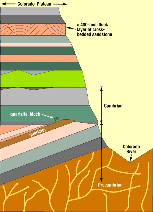
Figure 106: Grand Canyon Cross Section. The tipped and beveled layers are part of the Precambrian. The horizontal beveled plane, at the Cambrian-Precambrian interface, is sometimes called The Great Unconformity. A similar, but much smaller, example of tipped and beveled layers is shown in the cross-bedded sandstone in Figure 106. Beveling implies relative motion. Near the top of the Grand Canyon is a 400-foot-thick layer of cross-bedded sandstone. The white arrow points to the quartzite block shown in Figure 107.
In the Grand Canyon, the Cambrian-Precambrian interface is an almost flat, horizontal surface exposed for 66 miles above the Colorado River. Layers above the Cambrian-Precambrian interface are generally horizontal, but layers below are tipped at large angles, and their tipped edges are beveled off horizontally. [See Figure 106.] As slippage began during the compression event, layers below the slippage plane continued to compress to the point where they tipped. The sliding sedimentary block above the slippage plane beveled off the still soft tops of the tipped layers.
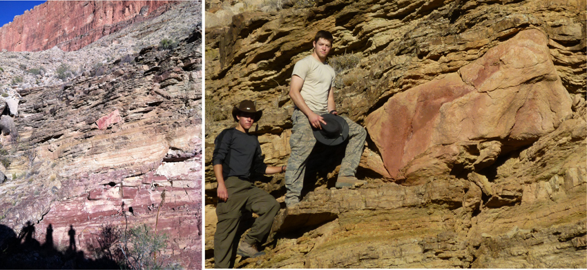
Figure 107: Transported Block in the Grand Canyon. In the left figure, notice the large, 5–10-ton block near the center, and the shadows of photographer Jim McDowell (my son-in-law) and two grandsons, Sean and Ryan McDowell. The right figure is an enlargement of the block with Ryan and Sean (left to right).
An article by geology professor Arthur V. Chadwick brought this block to my attention in 1978.28 Later, we got to know each other when he visited my office. The block—a very hard material called quartzite—was lifted, transported from right to left, and deposited on layers which, at the time, were soft mud. Other mud layers then blanketed the block. (See the deformed layers below and above the block.) Professor Chadwick correctly identified the lifting force: a very dense, rapidly-flowing, sand/mud/water slurry, which plucked the block off the lower quartzite layer upstream (far to the right of these pictures). Part of that “pink” quartzite layer is seen in the first picture (lower right). The easiest way to lift and transport such a heavy block is in a dense liquefied (and therefore, very buoyant), sediment/water mixture that is flowing at a high velocity.
This rapid transport, which was immediately above the Cambrian-Precambrian interface, occurred during the compression event. Below the sliding slurry, a sand layer decelerated and compressed first. That compression squeezed up water that lubricated the slide and heated the quartz sand, so it became quartzite.29 Compression also tipped the layers up, causing them to be beveled by the overriding, sliding layers. The camera is looking north; therefore, the slurry slid from east to west, which is consistent with the direction the Americas hydroplate slid away from the Mid-Atlantic Ridge. (Evolutionary geologists who do not understand the physics and the rapid continental drift that ended in the compression event, explain the flat Cambrian-Precambrian interface as a result of hundreds of millions of years of erosion. For them, unimaginable time explains everything. Lazy and sloppy thinking.)
See Figure 106 for a cross section of this region. The block is located at 36°7'34.80"N, 112°8'39.60"W. Hikers should not attempt to reach this remote, rugged, off-trail location unless they are in excellent physical condition and have permission from the Grand Canyon’s Backcountry Office.
Evolutionists have a different interpretation. They believe tipped Precambrian layers are remnants of a former mountain range, because mountains today often have steeply tipped layers. [See Figure 50 on page 117.] The tipped layers are horizontally beveled, so evolutionists say the top of the mountain must have eroded away. That, of course, would take a long time. Millions of years are also needed so seas could flood the area, because fossils of sea-bottom life are found just above the Cambrian-Precambrian interface. Within overlying layers, other fossils are found which required different environments, such as deserts or lagoons, so obviously, even more time is needed. (Unlimited time makes the nearly impossible seem possible—if you don’t think too much about mechanisms.)
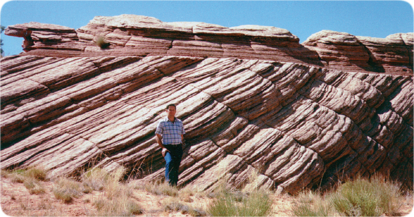
Figure 108: Cross-Bedded Sandstone. Dry sand can have a maximum slope of only 32 degrees. Cross-bedded sandstone, such as shown here, often has much greater slopes. Therefore, this sand was probably wet when the layers tipped.
Notice that the top (nearly horizontal) layers obviously slid over and beveled the tops of the tipped layers below. Something, such as water was needed to lubricate the sliding, otherwise the horizontal layers would be wrinkled or crushed. But what was the lubricant, and what was its source? What confined the lubricant between the sliding surfaces? What tipped the lower layers, and what pushed the top, horizontal layers over the tipped layers?
As the compression event began near the end of the flood, these sediments—all horizontally layered by liquefaction during the flood phase of the preceding months—were riding on decelerating hydroplates. The deceleration rapidly compressed the water-saturated sand, just as your hands might horizontally compress a wet sponge. Water squeezed out of the wet sand formed a temporary liquefaction lens that decoupled the sliding layers above from the layers below that were being simultaneously tipped by the horizontal compression. The compression event was over in minutes.
Also notice that the tipped layers are slightly concave upward. Over long distances, this concave-upward pattern is often seen throughout the world’s sedimentary layers. It occurs because a layer pushed horizontally (even if lubricated) would collide with what it is being pushed into. However, the more the layer is tipped upward, the less the resistance and the greater the thickening. Thus, these compressed and sheared layers are concave upward—increasingly tipped upward along their length and in the direction of their movement. The Appalachian Mountains are one of the most dramatic examples of this.
Key Requirements for Folding Strata, Buckling Mountains, and Overthrusting
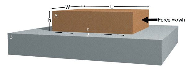
Figure 109: Hard-to-Satisfy Requirements for Overthrusting, Folding Strata, or Pushing Up Mountains.
Slab A has a length, height, width, and density of L, h, w, and r, respectively. It rests on horizontal surface B and is pushed from the right. The pressure or force trying to slide slab A over surface B exerts the maximum compressive stress, s, on the right end of slab A. Any compressive stress greater than s would crush slab A.
Let’s assume that slab A is not bonded to anything—is a free body. Only static friction (with a coefficient m) at the A-B interface resists movement. For motion to occur, the pushing force must exceed the resisting force, that is:

Page 610 gives the values for g, m, and s. For rock
Therefore, slab A will move only if
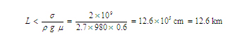
In other words, if a flat slab of rock, resting on another flat rock, is longer than 12.6 km (8 miles), a compressive stress trying to slide that slab would crush it before movement could begin—regardless of the slab’s other dimensions.
Conclusion: A rock slab longer than 8 miles cannot be pushed over unlubricated rock, so overthrusts, folded strata, and buckled mountains cannot occur in this way.
Simply folding a telephone book will produce slippage between adjacent pages. If those “pages” are rigid rock layers (or strata) at least 8 miles long, no matter how thin, folding cannot happen—without lubrication, crushing, or fracture. If the thrusted layer is sandwiched between other layers, the additional friction greatly increases the difficulty.
The hydroplate theory automatically satisfies the assumption that slab A is a free body, because its material was deposited as water-saturated sediments during the flood, and the compression event, in crushing the crust, formed slabs.
Overthrusts are found on all continents, and millions of buckled and folded layers can be seen in mountains and road cuts around the globe. [See, for example, Figure 50 on page 117]. Therefore, something lubricated the overthrusts, and the layers at the time of folding were loose, water-saturated sediments that later lithified (hardened). All this began under a global ocean at the end of the flood, so plenty of water was available for each requirement.
The compression event also created temporary liquefaction lenses, on which rock slabs quickly overrode other slabs with essentially no friction. [See "Liquefaction (Water) Lenses" on page 200.] This explains why rubble is usually missing from such sliding interfaces, and why geologist Clifford Burdick’s photographs of these interfaces show that sediments from the top slab were deposited through water onto the bottom slab.31
Unlike the high crushing stress which is necessary to slide slab A by pushing (if L > 8 miles), gravity sliding downhill achieves high velocities with little internal stress. That happened, according to the hydroplate theory, by the rising Mid-Atlantic Ridge and the subsiding Pacific hydroplate. Crushing and buckling finally occurred (1) near points where the lubricant was first depleted, (2) where an obstacle was encountered, or (3) where the overriding slab was relatively weak or thin.
The hydroplate theory meets all these requirements, thereby explaining how overthrusting and buckling occurred. In less than an hour38 (during the compression event), earth’s mountain ranges formed in continental-size hydroplates.
Overthrusts: Two Possibilities
Evolutionists believe not only that life evolved, but that they know the evolutionary sequence and when each major group of animals and plants was on earth. Therefore, evolutionists claim to know when the sediments fell through water and trapped, buried, and fossilized these animals and plants. This is primarily how evolutionists date sedimentary rocks. (Note the circular reasoning: The fossils date the rocks, and the rocks date other fossils which then date other rocks—all of which seemingly supports evolution.)
Some claim that radiometric dating confirms these dates, but that is not true. Comparing fossil dates with radiometric dates produces many contradictions. When these conflicts arise, one of the many problems with radiometric techniques (such as contamination) is usually given as the basis for rejecting the radiometric date and relying on the fossil technique, especially certain fossils called index fossils. [See "Index Fossils" on page 38.]
Imagine the evolutionists’ concern when they began to discover “older” fossils in rock layers above layers containing “younger” fossils.32 Leading creationists—notably George McCready Price33 (1870–1963) and Henry Morris, Jr.34 (1918–2006)—argued that these discoveries falsified evolution, because if evolution happened, the ages of rocks and fossils should increase with depth. Evolutionists then proposed that the older rocks must have slid up over younger rocks.32 How that could have happened has been a contentious issue for the past century. Physicists argue that friction prevents unlubricated slabs longer than 8 miles from sliding. [See page 206.] In response, geologists have maintained since 1959 that water in the pore spaces in rocks could flow out and lubricate the sliding surfaces.35
Each side of this controversy made a mistake. Price and Morris incorrectly denied that overthrusting had occurred. Hundreds of drill holes have since shown that older fossils do lie above younger fossils at overthrusts—a reversal of the normal sequence. However, as this chapter has shown, the normal sequence is a consequence of liquefaction, not evolution. So overthrusting has occurred. Evolutionists are wrong in claiming that water could come out of the pore spaces of rocks fast enough for a slab (8 miles or longer) to slide over another slab. Even if the sliding surfaces were perfectly flat and smooth, water’s viscosity is too high and the rock’s pore channels are too small for pore water to flow out fast enough.36
Even more ridiculous, the volume of water that would need to come out of rock is completely unreasonable. For example, the Lewis Overthrust in northwestern Montana and southern Alberta may be the most studied and famous overthrust in the world. This 50-mile-long overriding slab slid about 80 miles. Evolutionists claim this sliding occurred for 15-million years—at the extremely slow rate at which they believe tectonic plates move. Recognize how little water can be held in the pore space of rock, and imagine how much lubricating water would have leaked violently out of a high-pressure interface between the sliding surfaces in 15-million years! (The water’s pressure at that interface had to be high enough to lift the thick overriding slab.)
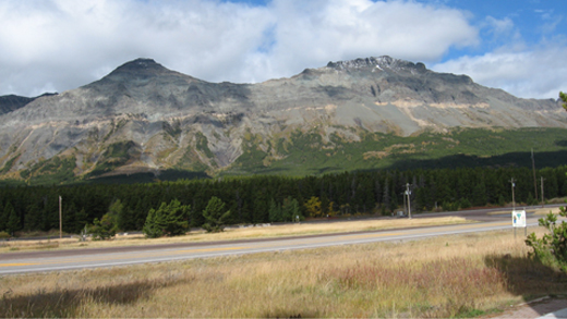
Figure 110: Looking North at the Lewis Overthrust from the Marias Pass in Glacier National Park, Montana. The white horizontal rock halfway up the mountain is the Altyn Limestone. It marks the base of the top half of the mountain that geologists know slid eastward (to the right) approximately 80 miles to its present position! How could that have happened?
Seldom mentioned are the forces and energy needed to propel the overriding slab. Evolutionists surmise that the overriding slab was on a steep downhill slope, but many overthrusts, including the Lewis Overthrust are not on a steep downhill slope, as you can see in Figure 110. So how did overthrusting occur? In a word, quickly—during the compression event which lasted less than an hour.37, 38
To their credit, evolutionists have correctly backed out the key requirements necessary to produce overthrusts, but have grossly underestimated the magnitudes needed for each requirement. However, the hydroplate theory, by beginning with the one major assumption on page 122 and then rigorously applying the laws of physics, easily explains these overthrusting magnitudes by applying both cause-to-effect reasoning and effect-to-cause reasoning. [See Table 5.]
|
|
Possible Explanations |
|
| Requirements37 |
Evolution |
Hydroplate |
| What is the source of the lubricating water? |
In the pore space of a solid rock. |
In loose, mile-thick, water-saturated sediments laid down months earlier through world-wide flood waters. |
| Where did the energy come from to move the overriding plate? |
Maybe the overriding slab was on a steep slope that has since disappeared. |
The sudden uplift of the steep Mid-Atlantic Ridge caused hydroplates to slide down the ridge on almost frictionless supercritical water. |
| What force moved the overriding plate? |
Deceleration of a slowly sliding plate. |
Deceleration of hydroplates that reached speeds of about 170 miles per hour.38 |
| What forced the lubricating water into the high-pressure interface between sliding surfaces? |
Slow gravity drainage within a solid rock. |
The sudden compression event that also pushed up earth’s major mountain ranges in less than an hour.38 It was like compressing a wet sponge. |
| What lifted the overriding slab up, so it could slide over the younger rock? |
Unknown |
Fluttering hydroplates during the continental-drift phase.39 |
Cross-Bedded Sandstone. Sand layers had the greatest water content, because sand grains are somewhat rounded, leaving relatively large gaps for water between the particles. Therefore, sand layers were the most fluid during the massive liquefaction that accompanied the compression event. Deceleration forced the sand forward, displacing the water backward. Horizontally compressed sand layers would have slid, tipped, buckled, and beveled individual layers and blocks of layers, exactly what we see in cross-bedded sandstone. [See Figure 108.]
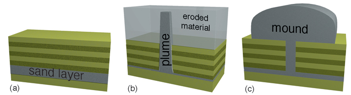
Figure 111: Formation of Liquefaction Plumes and Mounds. (a) During the flood phase, global liquefaction sorted water-saturated sediments into nearly horizontal layers. (b) During the compression event, massive liquefaction caused less-dense sand/water mixtures to float up as plumes, through denser overlying layers. (Figure 62 on page 129 shows a similar phenomenon.) Later, if the surface layers were not cemented as well as the sandstone plume, the surface layers could erode away, leaving the harder, more-resistant plume exposed. (c) If a plume spilled out on the ground, a mound would form.
Liquefaction Plumes and Mounds. The large water content of liquefied sand layers (40%) would have made them quite buoyant. Whenever a low-density, fluid layer (such as a water-sand mixture) underlies a denser, liquefied layer, the lighter fluid, if shaken, will float up in plumes through the denser fluid. Sand plumes that penetrated overlying layers are seen in many places on earth. [See Figures 111–113.]
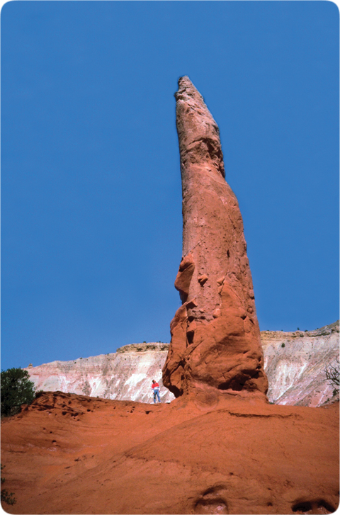
Figure 112: Liquefaction Plume 1. A hundred of these plumes are found in Kodachrome Basin State Reserve in south-central Utah, 10 miles east of Bryce Canyon National Park. I am standing at the bottom left of this tall plume.
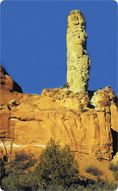
Figure 113: Liquefaction Plume 2. This plume can be traced down several hundred feet through the large rock in the bottom half of the picture. The plume grew up from a known horizontal sandstone layer that has identical chemical characteristics.40 After the plume pushed upward, cementing occurred, with the sandstone plume becoming harder than the material it penetrated. The softer layers surrounding the plume later eroded away, leaving the plume exposed. [See Figure 111b.] Notice the person waving at the bottom left of this plume.
Some plumes, especially those rising from thick, laterally extensive sand layers, spilled onto the earth’s surface. This spilling-out resembled volcanic action, except water-saturated sand erupted, not lava. Small liquefaction mounds, as they will be called, appear when liquefaction occurs during earthquakes.42 [See Levin’s description on page 197.] Hundreds of liquefaction mounds are found in basins—former postflood lakes—in the southwestern United States.
Why basins? During the compression event, liquefied water-sand mixtures in many places erupted up onto lake bottoms. Being surrounded and permeated by water, they would have quickly slumped into the shape of an upside-down bowl—a liquefaction mound. As the flood waters drained at the end of the flood, most liquefaction mounds were swept away, because they did not have time to be cemented. However, mounds inside postflood lakes (basins) were cemented as each lake cooled and its dissolved silica and calcium carbonate were forced out of solution. If a lake later breached and dumped its water, the larger cemented mounds could resist the torrent of rushing water and retain their shapes. The basins that held Grand and Hopi Lakes, shown on page 119, contain hundreds of mounds, such as the one in Figure 114. The sudden breaching of those lakes several centuries after the flood carved the Grand Canyon. [See pages 217–251.]
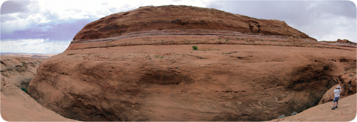
Figure 114: Liquefaction Mound.41 This and hundreds of similar sandstone mounds occupy the basin of the former Grand Lake. The breaching of Grand Lake carved the Grand Canyon. [See pages 217–249.]
The compression event produced massive liquefaction in water-saturated sand layers. During the few minutes the liquefaction lasted, some sand-water mixtures erupted, much like a volcano. Here, the eruption was onto the floor of Grand Lake. The large, mushy pile of sand quickly settled into the shape of an upside-down bowl. As the flood waters drained off the continents, this large, wet sand pile was protected, because it was deep in a lake. As the warm lake cooled, silica dissolved in the water was forced out of solution, thereby cementing the mound’s sand grains. A century or so later, when Grand Lake spilled out, rushing water around the mound eroded the softer sediments on which the mound rested, producing the deep “moat” that separates the man at the lower right from the mound.
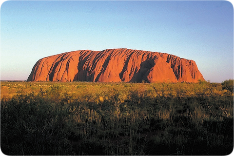
Figure 115: Ayers Rock. This popular tourist attraction in central Australia is 225 miles southwest of Alice Springs. Ayers Rock rises 1,140 feet from the desert floor and has a perimeter of 5.6 miles. Geologists who try to explain the origin of Ayers Rock say its sand came from the Musgrave mountain range 60 miles to the north and was dumped by water at its present spot. To account for its vertical layers, they say the rock “tipped,” but the forces, energy, and mechanisms to do this are never explained. However, most geologists admit they do not know the origin of Ayers Rock.
Ayers Rock has characteristics of both a broad liquefaction plume and a liquefaction mound. [See Figure 111.] Its surface layers (bedding) are nearly vertical, and they connect to a horizontal sandstone layer underground. It formed in the Amadeus Basin, whose contained waters covered and protected it while the flood waters drained from the earth. Probably most soft sediments, through which the plume rose, were swept away when the basin’s lake finally discharged. The many large holes in the sides of Ayers Rock show where water drained out. (Almost 20 miles away, this same, deep horizontal sandstone layer also connects to a series of liquefaction eruptions called the Olgas.)
The sand grains comprising Ayers Rock are jagged but, if exposed to rapid currents, would have become rounded. Had the grains been weathered for thousands of years, they would have become clay. Instead, these grain characteristics are consistent with the gentle currents produced by liquefaction and the rapid cementing in the years after the flood.
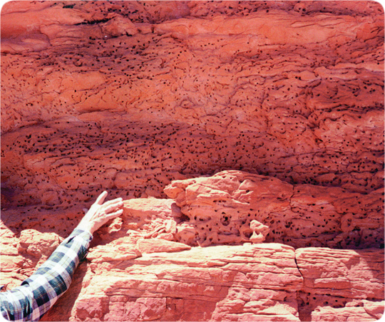
Figure 116: Small Water Vents. These water vents are smaller than a pebble; others, such as those in Ayers Rock, are larger than a car. Water vents are quite different from the shallow and smooth bowl-like depressions which wind and rain produce.
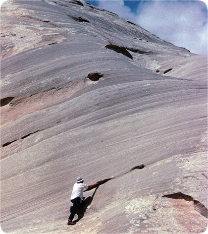
Figure 117: Medium-Size Water Vents. Geology professor Dr. Douglas A. Block points to one of many holes in the side of a huge liquefaction mound in southern Utah. If these holes were places where rock was weakly cemented, similar holes should be on the tops of mounds. Instead, the tops are smooth. Cementing in mounds and cross-bedded sandstone is remarkably uniform and hard, showing that the cement was uniformly dissolved throughout water that saturated the sand.
Liquefaction mounds have holes in their sides showing where internal water escaped. The channels have collapsed except near the mound’s surface where there was much less collapsing stress. Those holes now look like pock marks. Some have claimed they are erosion features from wind and rain. Obviously, wind and rain would smooth out pock marks, not make them. Besides, these “pock marks,” which will be called water vents, are found only in the sides of mounds, not the tops, where they should be if outside erosion formed them.
For centuries after the flood, water drained out of mountains and cliffs. Caves were carved by outward flowing water. New inhabitants to an area sought out and settled around these plentiful sources of water. (Thus, many ancient cultures believed that water originated in mountains and flowed out of caves.)46 Years later, as water sources dwindled, communities were forced to leave. Prosperous cultures, such as the Anasazi and cliff-dwellers, suddenly disappeared from an area, causing anthropologists to wonder if disease, war, famine, or drought destroyed those ancient communities. No; their water simply dried up.
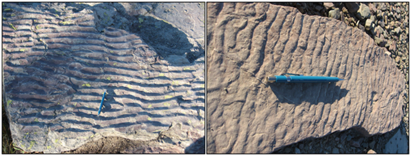
Figure 118: Ripples on the Continental Divide. These ripple marks, obviously made by water flowing powerfully43 in the direction of my pencil, are found at dozens of locations, within a few hundred feet of the Continental Divide, along Hidden Lake Trail at Logan Pass in Glacier National Park, Montana.44 (The Continental Divide is an imaginary line stretching from Alaska to the southern tip of South America—along the crest of the Rocky Mountain/Andes Mountain chains. Rain falling to the west of the Continental Divide flows toward the Pacific Ocean; rain falling to the east flows toward the Atlantic Ocean.) Below these rippled sandstone rocks are 7,000 feet of layered—and cemented—sedimentary rocks, whose sediments were deposited through water.
What sequence of events must have occurred to produce all this? First, about 7,000 feet of sediments had to be produced, then deposited on a seafloor and sorted into flat layers—all rapidly, because irregularities are only on top. Next, water had to flow powerfully over the uppermost layer to produce nonsymmetrical ripple marks in wet sand. But ripple marks are easily erased, just as sand castles on a beach are destroyed in a few days. Therefore, a thick layer of softer sediments (such as mud) had to rapidly blanket and protect the ripple marks. Then, the seafloor had to be pushed up to form the Rocky and Andes Mountains, a Herculean task requiring gigantic forces and energy. (Notice that plate tectonics provides neither.) Besides, the kinetic energy of a plate moving at only about an inch per year is so trivial that it could never push up a mountain.45) Later, the sediments were cemented by chemical agents that had to be spread uniformly throughout the billions of cubic miles of loose sediments. Finally, erosion and weathering removed the blanket, exposing the cemented sandstone ripples.
Could the ripples have been formed at their present elevation (about 7,150 feet above sea level)? No. Earth does not have enough water to rise uniformly to that elevation.Even if there was at one time that much water, where did it go, and what could lift such thick layers of sediments that high? Could ripples form in high lakes and become cemented? We don’t see that happening today, nor are the necessary chemicals present. Could the Rocky Mountains have been lifted slowly, over millions of years? The energy, forces, and mechanism for doing so have never been explained, but if the Rockies somehow did rise slowly, its peaks would experience the greatest erosion and weathering. Based on today’s conditions and measurements, the mountain and its cemented ripple marks would erode faster than the mountain rose.
The hydroplate theory, supported by hundreds of other evidences, easily explains ripples on the Continental Divide. Sediments, eroded by the escaping subterranean waters during the flood, were quickly deposited through those waters. On the continents, those deposits average more than a mile in thickness. Liquefaction sorted most of them into the prominent layers we see today, and fluttering hydroplates produced gigantic waves, causing ripples even on the deep seafloor. The compression event buckled, crushed, and lifted the Rocky Mountains within an hour. (That lifting of the seafloor up through the water also caused a powerful, ripple-producing flow.) Prior to the flood, supercritical water in the subterranean chambers dissolved and uniformly spread cementing agents, such as silica and calcium carbonate, throughout the water. Months and years after the flood, the warm flood waters cooled, so those minerals came out of solution, lodged as precipitated solids (or cement) in the tiniest spaces between sedimentary grains. What were the forces, energy, and mechanism that produced ripples on the Continental Divide? Gravity, the kinetic energy of massive hydroplates sliding downhill, and buckling. [See also "Seashells on Mountaintops" on page 50, "A Whale of a Tale" on page 137, and Figure 50 on page 117.]